I was recently asked a few very good questions. I enjoyed thinking about them further and so I wrote up some answers. I take this an opportunity to revive this blog. Let me know your thoughts on the questions and my answers. I’m happy to exchange view points.
Full disclosure. I work for Nokia Location & Commerce, but these are my personal views and thoughts which do not necessarily reflect Nokia’s views.
Here we go:
What do you do in your job as a Product Manager for Geocoding?
My role as a Product Manager is about communicating and providing context. I’m helping to define our product vision and mission, focus areas, and again context to make sure that as a team we work towards a common goal. And of course that includes grasping and then translating user and business needs into product stories so our team can build and improve the product against these. But it goes the other way around too when I’m explaining the value and benefits of technical product features to the user and business audience. I also look at the business side of the product. What are the revenues we help to create with our product? What is the usage and value of features? What do my colleagues in Sales need to sign up customers? What do we need to do to increase the bottom line?
What is geocoding, and why it is so important for navigation devices?
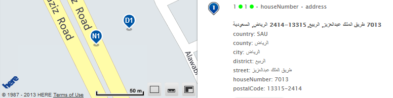
Very basically geocoding is the translation between how people describe an address and how spatial systems – like a navigation device – stores and works with an address location.
Let me give an example. My office address is “Am Kronberger Hang 8 in Schwalbach, Germany” which spatial is at “latitude: 50.1618996; longitude: 8.5334997”.
Let’s go a bit deeper now. There are two ways of geocoding.
First, geocoding allows users to find an address.
It is the equivalent of searching for a road name in the street index that is printed on the back of a paper map, then remembering the quadrant’s code, turning the map and pointing your finger at it. Compared to a paper map, a geocoding software has a much larger, if not gigantic global index, is much faster, more precise, and often supports multiple languages. Plus, there is a lot of additional information and data a good geocoding software provides. This is especially of value to enterprise users who are using geocoding to make smarter decisions and optimize their processes.
Then, geocoding also works the other way around, which is called reverse geocoding. This is used to answer the popular questions “Where am I?”, “What’s here?”, or even “Dude, where is my car?”. Here, a user resolves the latitude and longitude from a GPS/location sensor into an address.
Why is all this important for navigation devices? Because they operate on spatial data but people don’t. People are used to textual addresses not a location’s spatial latitude and longitude. So that translation is needed. And a piece of geocoding software is the first thing that kicks in on a navigation device when looking for directions.
Geocoding not only happens on navigation devices. We’re running our Geocoder software as a service in multiple data centers around the globe. The Geocoder service has global, fresh coverage based on our continuously updated automotive-grade map data. It is an essential building block of our Where Platform. Geocoder works seamlessly with the other Nokia location services like Places, Maps, Positioning, Directions, and Traffic. The Geocoder API is robust and offers high availability, performance and scalability and it’s in use by 300+ customers including Bing and Yahoo!.
And apart from the consumers being able to find addresses or locate themselves around the globe on the web and in apps, I’m really excited about the value of the smart things businesses can do with geocoded information; like analyzing the size of markets, geo-marketing, tracking and optimizing the efficiency of vehicles, workforce, or other assets.
You must use navigation and location a lot in your daily life given what you do. Which devices and applications do you tend to use most, which are your favorites and why?
I’m sure it’s not a surprise I use and love my Nokia Lumia 800. I use the Nokia Drive app for my daily commute to avoid traffic. It has this great new commute feature that watches the traffic situation for me and helps me pick the right time and route to go. Being a “spirited driver” I often run the Trapster app in the background for driving safety. I’m using Foursquare daily to “share my Where” and facilitate serendipity. And I’m tracking my running with the Nike+ Running app. Another favorite of mine is the Navigon app, specifically when used on the large screen of an iPad. I can also recommend Navigon’s PNDs. I bought one for my mum recently.
One of the hottest topics around the future of mobile mapping services is indoor location positioning and indoor positioning systems. Once this new technology becomes widely adopted what do you think will be the main usage applications for it?
The first thing that comes to everyone’s mind is of course displaying indoor maps and enabling navigation. So let’s say you’re in unfamiliar territory visiting friends at their new house. You don’t want to come with empty hands so you’re looking to buy some fresh flowers nearby them. You search and there is a florist in a gigantic mall not far away. What you want is to be guided to a parking row near the best entrance of the mall and then as you walk in, to be seamlessly guided inside the building to the store. Now you can slightly tweak that scenario at will, e.g. with a gate at the airport, booth at the show, rest room at the stadium, the Van Gogh at the museum, or the power tools section inside the home improvement store. It’ll still be a “portable and connected device – last mile indoor guidance” use case.
And then I see other great ways to use indoor location positioning.
For example in mobile payment solutions where location can be used for customer loyalty programs and better fraud protection mechanisms. Upon entering a store you can get relevant offers and when you’re ready to pay, that transaction’s location is checked against your actual location. This is a big, valuable, and exciting market. You want to see what Square and LevelUp are doing already.
With the global trend towards huge urban metropolises here is a use case for that: Public transportation, especially when this is underground. Again, think mobile payment based on where you enter and exit a station, so no paper tickets or swipe cards, and no more turnstiles. Plus up to date departure times, always the best connection, and never be lost in those long corridors. Doesn’t that sound good?
On the fun side I see virtual games in actual locations. Museums, parks, and resorts can create whole new engaging experiences.
The market is ever-changing, and there are plenty of challenges facing the traditional in-car navigation brands especially with high adoption rates for smart navigation. Do you think navigation devices have a future or will they soon be replaced by navigation apps on mobile phones?
I’m pretty sure there will always be demand for navigation devices, in-dash navigation and smartphone navigation apps. Each of these has their own advantages and limitations and ultimately it’s up to the consumers to decide what they prefer. Nokia offers data products and location platform service for each of these.
Yes, the trend towards using navigation on smartphones is growing, especially as navigation is already included on many smartphones today. And then there is a wide choice of apps to download. But I also see some interesting benefits that are not fully leveraged yet, e.g. as smartphones already come with a data connection this allows users to get fresher and more detailed data. I’m not talking map data here. Nokia was one of the first to store map data offline on the phones, so that you can navigate even if the connection drops and save on data usage fees. I’m talking about dynamic data e.g. traffic, gas prices, parking availability, detailed places information like reviews and pictures, and relevant local offers. Also for some people one device is already more than enough. So they don’t want to carry a separate navigation device and learn how to use it if they can get navigation on their smart phone with a user interface they already know. But again, consumers will decide and as devices and cars become more connected; some of today’s advantages of navigation on smart phones will not be unique tomorrow.
The key for the traditional navigation device brands is to acknowledge this and think about what markets and needs they can focus on to outperform smartphones and in-dash navigation. This may also include thinking about new markets. Look at Garmin. They are big in the great outdoors market too and historically they’ve come from marine and aviation. Navigation and location isn’t only about driving cars.
What are your own predictions for Location over the next couple of years?
Location will become ubiquitously ingrained into a lot of what we do as consumers and businesses. The adoption of GPS and location sensors in devices will grow further, not only phones but also things like cameras, watches, or luggage. Apps and services using location will transform quite a few industries. Personally I see mobile payments as the one that is going to be the most exciting with lots of opportunity. Health care and well-being is another area that has a lot of potential for connected location sensors and using that data. And it’s a growing industry. And there are great possibilities in inventory and supply chain monitoring and management.
The following three mega-trends will push innovation around using location: 1. The Internet of Things; 2. Mega Cities; and 3. Multi-modal Mobility.
These three trends can nicely tango. Let look at a few examples. Location sensors and connections to the Internet will be embedded in a lot more things. These things can then share data which can be used to optimize processes automatically or influence decisions. Of course this will be in cars but also motorbikes, bicycles, buses, trains, trucks, and anything else that moves people or goods. There it will not only help people find the best route, but also manage and avoid traffic, and support them make smarter decisions around which mode of transportation to use at any given time. This will have great benefits especially in and round Mega Cities with good public transport networks. And it will enable new usage-based vehicle insurance models, reduce emissions, and help improve safety.